
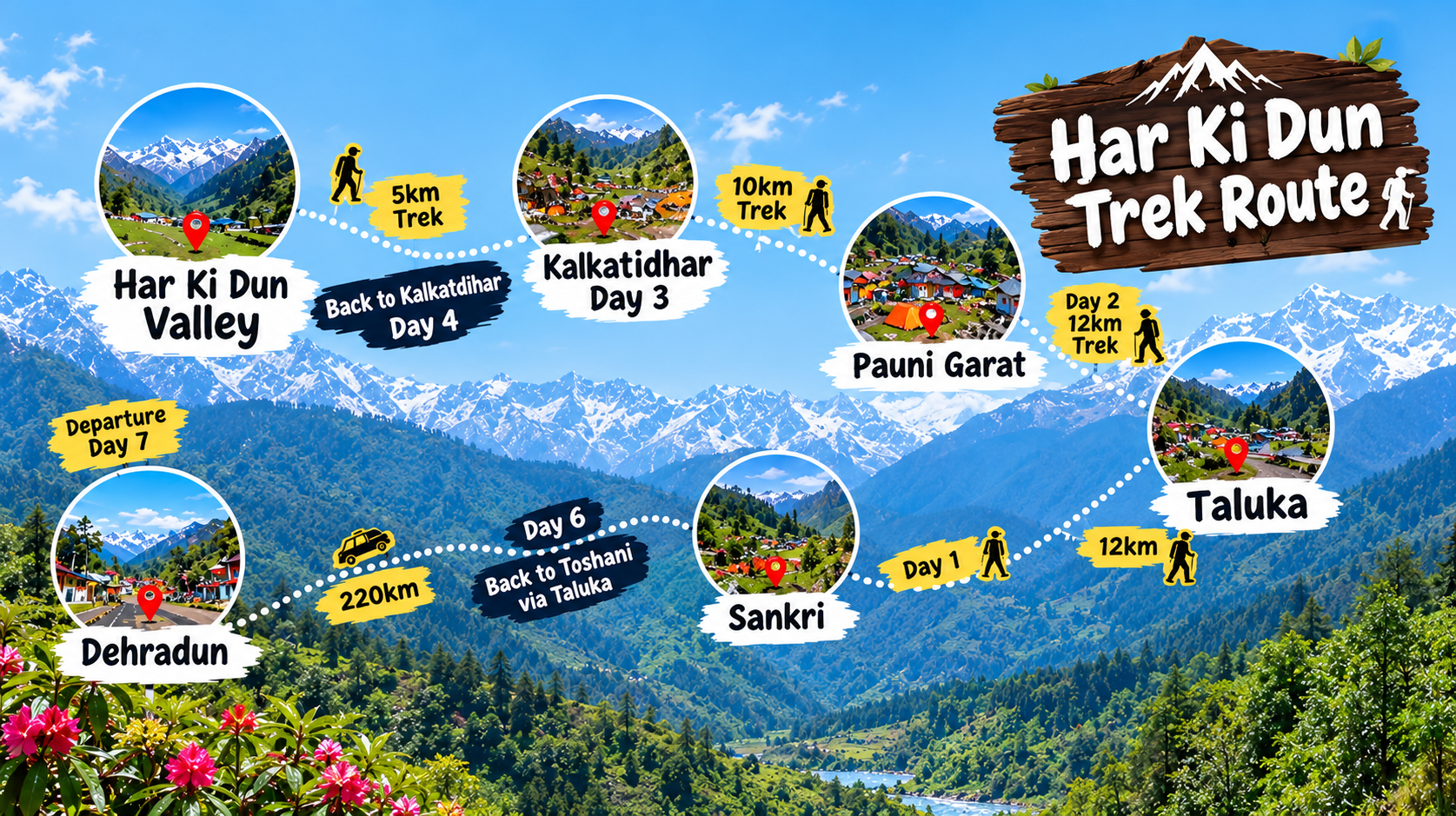
If you are searching for the Har Ki Dun Trek Route Map, you probably want to know more than just the trail direction. You need to understand where the trek starts, which villages come along the route, how far you actually have to walk, the altitude, and what the trail looks like.
Har Ki Dun is one of Uttarakhand’s most scenic Himalayan treks, taking you deep into the Govind Pashu Vihar region through forests, traditional mountain villages and the beautiful Supin River valley.
The route generally follows Sankri → Taluka → Osla/Seema → Har Ki Dun Valley, with variations depending on the roadhead, campsite and local trail conditions.
Har Ki Dun Trek Route at a Glance
Har Ki Dun Trek – Route Details
Essential information about the trek route and terrain
| Trek Name | Har Ki Dun Trek |
| Base Village | Sankri |
| Trek Starting Point | Taluka |
| Main Route | Sankri → Taluka → Osla/Seema → Har Ki Dun |
| Location | Uttarkashi, Uttarakhand |
| Maximum Altitude | Approx. 3,566 m / 11,700 ft |
| Approx. Trek Distance | Around 40–50+ km, depending on route |
| Difficulty | Easy to Moderate |
| Best Seasons | April–June & September–November |
| Main River | Supin River |
| Popular Villages | Osla, Seema and Gangad |
Har Ki Dun Trek Route Map
The most commonly followed route looks like this:
Dehradun → Sankri → Taluka → Osla/Seema → Kalkattiyadhar → Har Ki Dun Valley
The journey begins with the drive to Sankri, a well-known trekking base in the Uttarkashi region. From Sankri, the road continues toward Taluka, after which the actual walking trail enters the Himalayan landscape.
From Taluka, the trail gradually follows the Supin River through forests and mountain settlements. Osla and Seema are among the most important points on the route before the trail continues toward the high valley of Har Ki Dun.
Route & Distance Breakdown
Har Ki Dun Route Journey
Explore the main route sections and approximate distances
🚙 Sankri → Taluka
Road ApproachThe journey begins from Sankri with a road approach towards Taluka, the main trekking starting point.
🥾 Taluka → Osla / Seema
10–14 kmTrek through forest trails, mountain landscapes and traditional Himalayan villages towards Osla and Seema.
🏔️ Osla / Seema → Har Ki Dun
10–12 kmContinue deeper into the valley as the trail leads towards the spectacular Har Ki Dun landscape.
The total distance can vary depending on the selected route, approach sections and trek plan.
The exact distance can change because trekking operators may use different campsites or roadheads. Weather, trail conditions and local regulations can also affect the route.
1. Sankri – The Gateway to Har Ki Dun
Sankri is the starting base for the Har Ki Dun region. Surrounded by forests and high Himalayan peaks, this small mountain village is where trekkers usually prepare for the trail ahead.
It is also an important base for several other Uttarakhand treks, making it a lively hub during the trekking season.
From here, the route moves toward Taluka before entering the walking section of the trek.
2. Taluka – Where the Trekking Trail Begins
Taluka is generally considered the roadhead for the traditional Har Ki Dun route.
Once you leave the vehicle behind, the landscape starts changing. The trail passes through forested terrain and follows the valley alongside the Supin River.
This section gives you the feeling that you are gradually moving away from everyday life and deeper into the Himalayas.
3. Osla & Seema – Himalayan Villages Along the Route
One of the most memorable parts of the Har Ki Dun route is the traditional Himalayan village landscape around Osla and Seema.
Stone-and-wood houses, terraced fields, forests and mountain slopes create a completely different atmosphere from the towns and cities of Uttarakhand.
For many trekkers, reaching this section is not simply about covering distance. It is an opportunity to experience the culture and lifestyle of remote Himalayan communities.
4. Kalkattiyadhar – A Change in the Landscape
As the trail climbs further, the dense forest gradually gives way to more open mountain scenery.
Kalkattiyadhar is an important section of the route, offering broader views of the surrounding Himalayan landscape. The changing terrain also makes this part of the trek particularly exciting for photographers and nature lovers.
5. Har Ki Dun Valley – The Main Destination
Finally, the trail opens into the famous Har Ki Dun Valley.
Surrounded by dramatic Himalayan peaks and green mountain slopes, the valley is the highlight of the trek. The region is particularly known for views associated with Swargarohini and other surrounding peaks.
The peaceful atmosphere, river valley, alpine landscapes and remote setting are what make Har Ki Dun different from many shorter Himalayan treks.
Har Ki Dun Route Highlights
Discover the forests, villages, rivers and Himalayan landscapes that make the Har Ki Dun trek memorable.
Forest Trails
Walk through beautiful pine, oak and rhododendron-covered landscapes surrounded by Himalayan wilderness.
Osla Village
Experience traditional Himalayan architecture, local culture and the unique character of this mountain village.
Supin River
Follow the beautiful Supin River as it flows through the valley, adding a refreshing natural element to the trek.
Swargarohini Views
Enjoy dramatic Himalayan mountain scenery and spectacular views that open up along the valley.
Har Ki Dun Valley
Discover a wide and peaceful valley surrounded by impressive Himalayan peaks and natural beauty.
Mountain Landscapes
Capture forests, villages, rivers and panoramic Himalayan scenery throughout the journey.
Marinda Tal
Explore the optional scenic lake section near the valley for an additional mountain experience.
Har Ki Dun Trek Altitude
Altitude is another important part of understanding the route.
The highest point around the main Har Ki Dun valley is approximately 3,566 metres (11,700 feet) above sea level. The gradual change from lower forest areas to the high valley makes the route visually and physically interesting.
Har Ki Dun Elevation Profile
Follow the gradual rise in elevation from Sankri to the Har Ki Dun Valley.
Sankri
~1,900 mTaluka
~2,100–2,200 mOsla / Seema
~2,500–2,600 mHar Ki Dun Valley
~3,566 mElevations are approximate and may vary slightly between sources and exact trail locations.
Is Har Ki Dun Trek Difficult?
Har Ki Dun is generally considered an easy-to-moderate to moderate Himalayan trek, but difficulty depends on fitness, weather, trail conditions and altitude.
You don’t need technical mountaineering skills for the standard route. However, you should be comfortable walking for several hours on uneven mountain trails.
The most important things are:
- Good basic fitness
- Comfortable trekking shoes
- Proper acclimatization
- Adequate hydration
- Layered clothing
- Awareness of changing Himalayan weather
Best Time for Har Ki Dun Trek
The most popular periods for the Har Ki Dun Trek are spring and autumn, when the weather and mountain scenery are particularly appealing for trekking.
| Season | What to Expect |
|---|---|
| April–June | Pleasant trekking conditions, greenery and blooming flowers |
| July–August | Monsoon; heavy rain can make trails difficult |
| September–November | Clearer mountain views and comfortable trekking weather |
| Winter | Snow-covered landscapes but colder and more demanding conditions |
For most trekkers looking for a balance between comfortable trails and beautiful mountain views, April–June and September–November are strong choices.
For a more detailed seasonal guide, including weather conditions and what trekkers can expect during different months, explore our Har Ki Dun Trek Best Time 2026 guide.
Why the Har Ki Dun Route Is Special
What makes this trek memorable isn’t simply reaching a particular altitude.
The route combines ancient villages, Himalayan forests, rivers, mountain views and a remote valley in one journey.
You can walk beside the Supin River, pass traditional settlements such as Osla, move through dense forests and eventually find yourself surrounded by the enormous Himalayan landscape of Har Ki Dun.
That gradual change in scenery is one of the biggest reasons trekkers remember this route long after returning home.
🏔️ Har Ki Dun Trek – Quick Facts
Everything you need to know about the route, altitude, difficulty, distance and trekking conditions at a glance.
Plan Your Har Ki Dun Trek
A good understanding of the Har Ki Dun Trek Route Map helps you prepare better for the actual experience. Instead of looking only at kilometres, consider the altitude, terrain, weather, village sections and overall trail conditions.
With proper preparation and a reliable trekking team, Har Ki Dun can be an unforgettable introduction to the deeper Himalayan landscape.
Trek Tonic Adventures can help you plan your Har Ki Dun Trek with organized transport, experienced trek leaders, accommodation, meals and essential trek support.
Frequently Asked Questions
How long is the Har Ki Dun Trek?
The total trekking distance is commonly described in the 40–50+ km range, depending on the selected route, roadhead, campsites and optional sections.
Where does the Har Ki Dun Trek start?
Sankri is the main base village, while Taluka is commonly used as the roadhead for the trekking section.
What is the highest altitude of Har Ki Dun?
The Har Ki Dun valley is approximately 3,566 metres (11,700 feet) above sea level.
Is Har Ki Dun suitable for beginners?
Yes, reasonably fit beginners can attempt the standard trek with proper preparation, although mountain weather, distance and altitude should not be underestimated.
What are the main attractions on the route?
The Supin River, Osla village, Himalayan forests, traditional mountain settlements, Swargarohini views and Har Ki Dun Valley are among the major highlights.