Planning the Chopta Tungnath Trek becomes much easier when you know what the trail actually looks like before reaching the mountains. The route is short in terms of distance, but the steady climb makes every section of the trail different.
The Chopta Tungnath Trek Route takes you from the meadows of Chopta towards Tungnath Temple through a changing Himalayan landscape. The trail begins at around 2,680 metres and climbs to approximately 3,680 metres at Tungnath. Trekkers who continue further can reach Chandrashila at around 4,000 metres.
Instead of looking at the trek only as a distance on a map, this guide explains the route section by section, including what to expect on the trail, altitude changes, elevation gain, route direction and important points to remember.
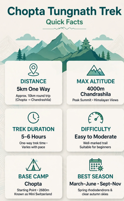
Chopta Tungnath Trek Route quick facts
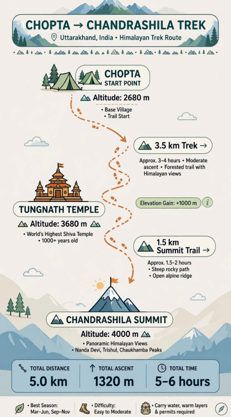
The standard Tungnath Trek Route follows a simple progression:
Chopta → Tungnath Temple → Chandrashila
Chopta is the trailhead. From here, the route climbs continuously towards Tungnath Temple. After reaching the temple, Chandrashila is an optional extension for trekkers who want to continue towards the summit.
The important thing to understand is that the route has two different experiences:
Chopta → Tungnath
Longer but relatively consistent uphill walking.
Tungnath → Chandrashila
Shorter distance but a steeper final climb.
Current trekking guides describe the Chopta–Tungnath trail as a mostly stone-paved, clearly defined path, while the Chandrashila section becomes steeper and more rugged.
Starting Point: Chopta
Main Destination: Tungnath Temple
Highest Point: Chandrashila Summit
Chopta to Tungnath: Approx. 3.5 km one way
Tungnath to Chandrashila: Approx. 1.5 km one way
Tungnath Altitude: Approx. 3,680 m
Chandrashila Altitude: Approx. 4,000 m
Chopta to Chandrashila & Back: Approx. 10 km
Difficulty: Easy to Moderate
Chopta Tungnath Trek Distance
The Chopta Tungnath Trek Distance is approximately 3.5–4 km from Chopta to Tungnath one way.
If you include Chandrashila, the walking distance increases because the summit is located beyond Tungnath.
The distance is often confusing because some guides refer only to the Tungnath section, while others include Chandrashila.
Here is the simplest breakdown:
Chopta to Tungnath
Approx. 3.5 km one way
Approx. 7 km return
Tungnath to Chandrashila
Approx. 1.5 km one way
Chopta to Chandrashila
Approx. 5 km one way
Complete Chandrashila Return
Approx. 10 km
These figures are consistent with current trekking guides, although some sources give a 3.5–4 km range for the Chopta -Tungnath section depending on the exact starting point.
Chopta to Tungnath Distance
The Chopta to Tungnath distance is approximately 3.5 km one way.
The number may look small, but this is not a flat walking route. The trail climbs from approximately 2,680 m at Chopta to around 3,680 m at Tungnath, giving an elevation gain of roughly 1,000 m.
Route in One Line
Chopta
↓
3.5 km uphill
↓
Tungnath Temple
A moderate walking pace generally takes around 2–3 hours to reach Tungnath, although actual time varies with fitness, weather, breaks and trail conditions.
Tungnath to Chandrashila Distance
Once you reach Tungnath Temple, the trail can be extended towards Chandrashila.
The distance is approximately 1.5 km one way.
Although this is much shorter than the Chopta–Tungnath section, the gradient becomes steeper and the higher altitude can make the climb feel harder.
Route in One Line
Tungnath Temple
3,680 m
↓
1.5 km uphill
↓
Chandrashila Summit
4,000 m
Current sources generally place the Tungnath–Chandrashila section at around 1.5 km and describe it as steeper than the route to Tungnath.
Chopta Tungnath Trek Altitude
Altitude is one of the most important parts of this trek because you gain significant height over a relatively short distance.
Chopta
Approx. 2,680 m / 8,790 ft
This is the starting point of the main Tungnath trail.
Tungnath Temple
Approx. 3,680 m / 12,073 ft
Tungnath is the main destination on the route.
Chandrashila Summit
Approx. 4,000 m / 13,123 ft
This is the highest point if you continue beyond Tungnath.
These altitude figures are consistently reported across current trekking guides.
Chopta Tungnath Trek Map
Chopta Tungnath Trek Route FAQs
What should I carry for the Chopta Tungnath Trek?
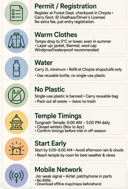
Essential items generally include comfortable trekking shoes, warm layers, rain protection, water, snacks, sunscreen, sunglasses, basic medicines and a trekking pole. During winter or snowy conditions, additional traction equipment and proper winter gear may be required.
How difficult is the Chopta Tungnath Trek?
The Chopta to Tungnath section is generally considered an easy to moderate trek because the trail is well-defined and largely stone-paved. The climb from Tungnath to Chandrashila is shorter but noticeably steeper and can be more challenging, particularly in snow or icy conditions.
Is Tungnath Temple open throughout the year?
No. Tungnath Temple closes during the winter season because of heavy snow, while the trek route itself may still be accessible depending on weather and trail conditions. For a temple visit, travellers should check the latest opening and closing dates before planning their trip.
What is the elevation gain from Chopta to Tungnath?
The trek gains roughly 1,000 metres in elevation from Chopta to Tungnath. Continuing from Tungnath to Chandrashila adds approximately another 300–400 metres, making the full climb to Chandrashila around 1,300 metres of elevation gain.
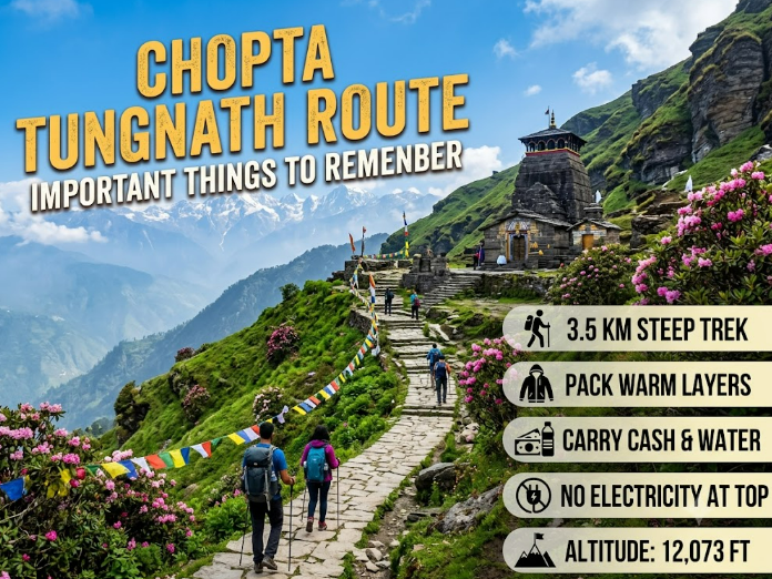
Before starting your trek, keep these points in mind:
1. Do not judge the trek only by kilometres.
The altitude gain makes the uphill route more demanding.
2. Keep your pace comfortable.
There is no benefit in rushing the climb.
3. Take weather seriously.
Mountain conditions can change quickly.
4. Prepare differently for snow.
Winter conditions can change the appearance and walking difficulty of the route.
5. Keep the trail clean.
Carry your waste back instead of leaving plastic or other items on the mountain.
6. Follow local instructions.
Trail accessibility and temple-related conditions can vary by season.
Explore the Chopta Tungnath Trek with Trek Tonic
The Chopta Tungnath Trek Route is more than a short distance on a map. The trail gradually takes you from the meadows of Chopta to the high-altitude surroundings of Tungnath and, for those continuing further, to Chandrashila Summit.
Knowing the route, distance and altitude beforehand helps you understand how the trek progresses and prepare accordingly.
For the complete trekking plan, day-wise schedule, inclusions and other trip details, explore the Chopta Tungnath Trek with Trek Tonic Adventures.
Explore the complete itinerary:
https://trektonicadventures.com/chopta-tungnath-trek-itinerary/
View the trek details:
https://trektonicadventures.com/trip/chopta-tungnath-trek/